The Mystery of Big Island (Part Three)

Runners standing at the edge of a wooded trail.

It’s been nearly a year and a whole long winter of impassable trails through the river valley since I posted an update about the work being done to turn a small bit of land with a big local history into a small provincial park.

The last time we thought about that effort on this site, a small group of us had gone off on a short adventure run to test our prospects of finding a runnable trail between my house and the bit of natural space clinging to the edge of the river.

What we found instead was a dead end. And a furthering of the mystery behind this bit of future park where it seemed our odds of future adventure were good, if not simple to find.

You can read about the first two parts of that adventure here on this blog in The Mystery of Big Island Part One and Part Two.

The mystery seemed as if it would continue to allude us with no more media coverage and limited ability to drop into a snow-filled river valley for our own fact-finding-fun prior to May. My aim was to start up my investigations once again this summer with some alternative entry options and perhaps drag along a friend or five to continue our search for elusive access to Big Island.

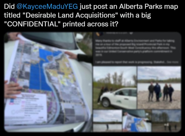
And then I was meandering through Twitter this morning only to discover this (politically charged) tweet of how one of our local, bumbling politicians had accidently (really?) posted a confidential planning map with some clear intentions for the ongoing work around Big Island.

(Screenshot of the tweet archived here.)

The little grey blot in the middle of the sea of appropriately-coloured blue land marks the Big Island proper with some surrounding farmlands clearly marked for possible buyout or annexation or something relating to creating a protected public zone around this little natural treasure.

I’ve been studying maps of this exact area, trying to understand if there is a good place to park and find access into the valley .

Clearly if I have a government sticker on my truck (which I do not) parking near to and descending upon this bit of land wouldn’t be a problem. Looking at the tweeted photos it’s clear that if a politician can clamber down into the area in his work clothes, a handful of runners with trail gear must be able to find a way too.

Of course, this accidental leak implies that multiple people are thinking much bigger than I am about this little future park. I’m working on a video about a different river valley park and some time I spent there recently, but seeing this information has made me even more determined to bring some friends and a camera back on another summer adventure, an adventure to uncover the mystery of Big Island… preferably before they plow a road there and everyone figures it out.

Stay tuned for Part Four…

The Mystery of Big Island (Part Two)

Almost three months ago to this day, readers, I introduced you to a local puzzle that I was hoping to solve. Big Island, to catch you up, is a modest chunk of river valley wilderness with a backstory that both intrigued the explorer in me and piqued the curious pathfinder that lives in the uncaged corners of my soul.

I live a short(ish) walk from the winding North Saskatchewan River, a silty mountain-fed prairie waterway that snakes its way across the province and bisects the city in which I live.

If you recall, the city leaders have built policy around the idea of preserving what they term a “ribbon of green” that is our river valley. They do this as a system of trails and public parks rivaling the accessible and recreational natural areas of most cities around the world. In fact, many locals often use the comparison to NYC’s Central Park of which Edmonton’s river valley is approximately twenty-two times the size, but spread across nearly fifty kilometers of riverbanks. Of course, preserving a public green space in the middle of Manhattan is a whole different scale of forethought compared to us just avoiding putting some suburban houses on the unpredictable steep cliffs and sandy soil sides of a prairie river, but don’t say that too loudly if you come to visit our river trails.

I’ve had it in my head to explore south of this preserved system and beyond the city borders, particularly so when I learned that a few kilometers past the so-called “end of the trail” is an oxbow formation in the land, a place where the river once sharply bent and carved off a little bubble of land but has long since shortcut and left a quasi-island nestled into the edge of the same river valley.

I’ve got maps and diagrams to explain all this in part one, and it is where I also explain that this little oxbow island, named Big Island, has a long secret local history and is now slated to become officially protected with a provincial park designation.

All this, and yet no one really knows how to get there.

Of Adventure Runs

Having discovered that such a mystery exists, I got it into my head to find a way to visit.

This past Wednesday evening I proposed an adventure to my running crew. Each Wednesday over the summer, after all, we meet to do an exploration run of some bit of local trail that few of us have previously visited. I asked, with couched expectations, if anyone was interested in trying to find a trail to Big Island.

There were five of us who broke from the even, clear asphalt shortly after seven that evening, and climbed into a narrow stretch of single-track trail leading into the river valley woods along a route I’d often seen but never travelled.

The heat was still lingering with a sweltering, humid hot that made the rolling trails even more of a challenge than they should have been. Yet, the rough trail, unchecked by anyone but the more hardcore of local adventurers, was mere scrambles of dirt and roots and bits of low vegetation swatting our ankles as we ran by trying not to trip or stumble down a steep bit of path and often grabbing onto trees or branches to keep from a fall.

This path towards Big Island was not well-worn.

And in fact, this turned out to not be a path to Big Island at all.

With our phones in hand we plotted our location in the GPS map comparing our real time adventure to a satellite map of our intended destination. We estimated that at our nearest we were merely five hundred meters away from the shores of Big Island. But the path degraded into near non-existence, become a dense shrub-lined fox run at best, and at worst an anthill-infested maze not intended for a bunch of ill prepared runners in running shorts on a weekday evening schedule.

We turned back, unable to reach our destination on the first attempt, everyone a bit disappointed but beyond fine with the adventure and attempt. Meanwhile I secretly plotted how part three of this mystery might unfold. Someday.

The Mystery of Big Island (Part One)

I had other writing plans this morning, but a mystery has been unravelling in my own backyard that has piqued and diverted my interest for an upcoming summer of potential exploration.

Backstory.

I live near the mighty North Saskatchewan River, a twelve hundred and eighty-seven kilometer long ribbon of glacial water that flows, stretches and merges with it’s sister as it’s waters drip off the glaciers of the Rocky Mountains and eventually drain in the Hudson’s Bay.

I can walk a mere thirty minutes from my house and dip my feet in it’s brown hued muddy waters and I often do…. though the wet-feet part is not always on purpose.

I took this photo from a footbridge suspended under a highway river crossing. The city’s ring road cuts across the river twice, and this bridge located in the southwest is one of those spots. The bridge also marks an interesting point in the city’s remarkable river valley parks system: the south-side edge of where it is uniformly accessible. Behind me in this shot is a network of maintained asphalt trails, benches, waste bins, signage, and friendly fellow residents enjoying the the park system.

Ahead of me, in the trees pictured, the trails look more like this second photo:

Much of this is a mix of crown land and private property, often merging and tripping over each other in unclear boundaries. I’ve walked and run through there a few times.

It’s as close to local bushwhacking adventure as I can get on foot and still be home for lunch.

Big Island.

Go back to look at that first photo.

The wedge of trees that seems to slice across the river (where the river actually bends South a bit) is a piece of land that is called Big Island and apparently has something of a local history. You can also read more about it at citymuseumedmonton.ca.

The green arrow highlights the view of the photo from the bridge I had referenced earlier.

I fully admit, I’ve been curious about these parts, and have wandered through the woods with my cameras (particularly through those trails on either side of the arrow I’ve drawn on the map) looking for something interesting.

However, renewed local chatter in the last few days that our provincial government may be working to designate Big Island as a protected provincial recreation area has me digging deeper into this mystery: the Mystery of Big Island (and why after fifteen years living so close I have never gone to check it out!)

I think I might officially have a summer exploration project. Visit. Take some photos. Learn more about this amazing local treasure that has been hiding right under my nose.

Stay tuned!